by
Fulya Çingiroğlu | Dec 29, 2023
3 projects are granted support under TÜBİTAK ‘‘Scientific and Technological Research Projects Funding Program’’
 Three projects carried out by our faculty members Ömer Kamacı, Demet Biltekin and Prof. Dr. Tolga Görüm were granted to be supported under TÜBİTAK ‘‘Scientific and Technological Research Projects Funding Program’’
The projects deemed worthy of support by TUBITAK are listed below:
|
|
PRINCIPAL
INVESTIGATOR
|
PROJECT
TITLE
|
|
|
Ömer Kamacı
|
Gördes Asmasifi (Manisa) İçerisindeki Tersiyer Kabuksal Ergiyiklerinin Termodinamiği, Petrolojisi ve Çekirdek Kompleksi Gelişimindeki Rolü
|
|
|
Demet Biltekin
|
Determination of Paleoclimate Records of the Aegean Sea with Multi-proxy Methods and Assessment of Vulnerability to Future Climate Change
|
|
|
Tolga Görüm
|
06 Şubat 2023 Mw 7.8 ve Mw 7.6 Depremlerinin Tetiklediği Heyelan Alanlarının Belirlenmesi, İzlenmesi ve Ardışık Jeomorfik Tehlike Potansiyellerinin Değerlendirilmesi
|
The project titled "Thermodynamics, Petrology and Role of Tertiary Crustal Melts in the Gördes Asmasif (Manisa)", led by Asst. Prof. Dr. Ömer Kamacı, focuses on the thermodynamic and petrological evolution of Tertiary aged continental crustal processes in the Menderes Massif. The main objective of the project is to reveal the place of migmatization and subsequent continental magmatism in space-time and its role in core complex development.


The project titled ‘’ Investigation of Aegean Sea Paleoclimate Records Using Multi-Proxy Methods and Determining Their Vulnerability to Future Climate Change’’, led by Asst. Prof. Demet Biltekin, by using multi-parameter methods in the sediment cores to be taken from the Edremit, Güllük, and Gökova Bays in the Aegean Sea, the Aegean Sea from north to south will reveal regional old climate records during the Holocene period and how it was affected by global climate conditions and related paleo-oceanographic data, and also how future climate change will effect the region.
The project aims to reveal changes in (paleo)environmental conditions.


The project titled "Identification and Monitoring of Landslide Areas Triggered by the February 06, 2023 Mw 7.8 and Mw 7.6 Earthquakes and Evaluation of Sequential Geomorphic Hazard Potentials", led by Prof. Dr. Tolga Görüm, brings together different institutions and researchers in collaboration with Prof. Dr. Ömer Lütfi Şen from ITU Eurasia Institute of Earth Sciences, Assoc. Prof. Dr. Hakan Tanyaş from Twente University, Prof. Dr. Saygın Abdikan from Hacettepe University, Prof. Dr. Lütfi Süzen from Middle East Technical University and Prof. Dr. Fusun Balık Şanlı from Yıldız Technical University.
Purpose of the Project
On February 06, 2023, two major earthquakes of Mw 7.8 and Mw 7.6 occurred in an area of ~100,000 km2, directly affecting 11 provinces. These earthquakes, which occurred on the Eastern Anatolia Fault Zone, created a surface fracture of approximately 400 km, and these two earthquakes caused the death of more than 52,000 of our citizens and were recorded as the biggest national disaster of our country. These earthquakes triggered thousands of landslides (rock falls, rock avalanches and slides) along the fault lines and especially in rugged mountainous areas, causing loss of life and property.
Unfortunately, 21 of our citizens lost their lives when the rubble and debris released by slope failures as well as the deep fracture systems caused by the earthquake turned into hyperconcentric flows, especially rubble and mud flows, with the extreme rainfall on March 15, 2023. With an area of 100,000 km2, identifying, monitoring and analyzing in detail the hazard potential of landslides that may continue in the future is of utmost importance in reducing the current landslide risk in the region. In addition, the main objectives of the project are to document the landslides caused by the largest earthquake sequence ever recorded in Turkey, which occurred with a difference of less than one day.
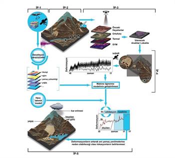
The main objectives of the project are as follows:
- Compilation and integration of pre- and post-earthquake data for the study area (IP-1),
- Establishment of an event inventory map for earthquake-triggered landslides (IP-2),
- Detailed geomorphological hazard assessment of the identified localities and selection of key localities to be monitored (IP-3),
Monitoring surface deformation of key localities using InSAR (IP-4) Development of a machine learning model to predict surface deformation rates of landslides and assess the hazard of landslides
You can follow the results of the project, which will last 36 months in total, at https://geohazard.itu.edu.tr/


